Showing posts with label map. Show all posts

Friday, January 27, 2017

North American River Otter - The BASICS!

North American River Otter
(Lontra canadensis)


The posts this week are brief overviews of EACH of the otter species, focusing on recent information about each species and a vid or 2... 
 
This is the ONLY freshwater otter in ALL of North America, 
and, as long as it can access fresh water for cleaning up,
it is adapted to use brackish and marine habitats to!!!


North American River Otters are highly adaptable to different types of habitats, but they are very sensitive to pollution and changes in water quality. They are extremely playful, and turn almost all regular activities into a game. They do not tend to pair-bond (though sometimes they do), but males will help to raise the pups if given the opportunity. Males tend to be more solitary than females, but they don't do well alone for long periods of time and will seek out the company of other otters.


This is the ONLY otter species in the world with a population status of "Stable".


Status: Least Concern and Stable


The North American River Otter has a very large range and can be found throughout most of the US (the map below isn't quite accurate, we'll be creating a more accurate map, it is not found in very arid regions). It's habitat overlaps with the sea otter along the west coast of the US.


There are TONS (if you could weigh content on the internet ;) ) of videos "out there" of North American River Otters! GO! ENJOY!!! (but in the mean time, here are a few from us!)

Let's just start with this...


If you want more in-depth reading a few research articles you could explore on these otters includes:

>   Genetic variation among populations of river otters in North America: considerations for reintroduction projects, TL Serfass, RP Brooks, JM Novak. Journal of Mamm., 1998 
>   Deciphering ecological barriers to North American river otter (Lontra canadensis) gene flow in the Louisiana landscape, EK Latch, DG Scognamillo, JA Fike. Journal of Am Gen, 2008 
>  Ten new polymorphic microsatellite loci for North American river otters (Lontra canadensis) and their utility in related mustelids, AS Beheler, JA Fike, G Dharmarajan. Molecular Ecology, 2005 
>  Characterization of basal seminal traits and reproductive endocrine profiles in North American river otters and Asian small‐clawed otters, HL Bateman, JB Bond, M Campbell, M Barrie. Zoo …, 2009
>  Perfluorooctanesulfonate and related fluorinated hydrocarbons in mink and river otters from the United States, K Kannan, J Newsted, RS Halbrook. Environmental science & ACS Publ, 2002 
>  Prey selection by marine-coastal river otters (Lontra canadensis) in Newfoundland, Canada, D Cote, HMJ Stewart, RS Gregory. Journal of Mamm, 2008

Thursday, January 26, 2017

South American River Otter - Basics!

South American /Southern River Otter 
(Lontra provocax)


The posts this week are brief overviews of EACH of the otter species, focusing on recent information about each species and a vid or 2... 
 
This otter shares large parts of it's the marine otter's marine habitat. 


Southern River Otters tend to have a very short life span. Few live to maturity, and only 1% live to 10 years of age. They are generally solitary, coming together mainly to mate. The female raises the pups alone, and there are no social groups beyond this.   They have territories like other otters, but the size of these territories is unknown and it appears that they are not particularly defensive of them.

Status: Endangered and Decreasing


South American River otters live in fresh and salt water habitats along the lower (primarily western) coast of South America, in red in the map on the left.


The habitat range of the Marine Otter overlaps in Chile with the other "most southerly" Lontra-otter, the South American River otter.


Southern River otter in captivity, eating.


If you want more in-depth reading a few research articles you could explore on these otters includes:

>   Understanding the inter-specific dynamics of two co-existing predators in the Tierra del Fuego Archipelago: the native southern river otter and the exotic American. AEJ Valenzuela, AR Rey, L Fasola, A Schiavini - Biological invasions, 2013
D Centrón, B Ramirez, L Fasola… - Journal of Am Genetic Assoc, 2008
>   Phylogeography of the Patagonian otter Lontra provocax: adaptive divergence to marine habitat or signature of southern glacial refugia? JA Vianna, G Medina-Vogel, BMC, 2011


Marine Otter - Basics

Marine Otter
(Lontra felina)


The posts this week are brief overviews of EACH of the otter species, focusing on recent information about each species and a vid or 2... 
 
This otter is second only to the sea otter in it's use of marine environments, only occasionally traveling up freshwater rivers in search of food. 


Marine Otters seem to be the only otter other than the sea otter that do not require access to fresh water to wash themselves. Though Marine Otters tend to be solitary, they are generally friendly (but not highly sociable) with other otters. They do sometimes hunt cooperatively, groups of two or three otters working together to catch larger fish. Also, Marine Otters have hairy noses! (Also known as the Sea Cat)


Status: Endangered and Decreasing


Marine Otters (distribution shown in yellow on the map to the left) live along the west coast of South America, from Peru to Chile, with a few noted "around the corner" in Argentina.


They tend to live in diversity rich areas along rocky shores with caves.


The habitat range of the Marine Otter overlaps in Chile with the other "most southerly" Lontra-otter, the South American River otter.


Videos of these agile little otters in the water are amazing to watch!


and on a rocky shore...


If you want more in-depth reading a few research articles you could explore on these otters includes:


>   Non-invasive genetic analysis reveals high levels of mtDNA variability in the endangered South-American marine otter (Lontra felina), Juan Valqui, Günther B. Hartl, Frank E. Zachos, 2010
>   Phylogeography of the marine otter (Lontra felina): historical and contemporary factors determining its distribution, JA Vianna, P Ayerdi, G Medina-Vogel. Journal of Am Genetic Assoc, 2010>   The marine otter Lontra felina (): A review of its present status and implications for future conservation,J Valqui - Mammalian Biology-Zeitschrift für Säugetierkunde, 2012
>   The late Miocene radiation of modern Felidae: a genetic assessment,WE Johnson, E Eizirik, J Pecon-Slattery, 2006


Wednesday, January 25, 2017

Eurasian Otter - The Basics!

Eurasian Otter
(Lutra lutra)

As promised, the posts this week are brief overviews of EACH of the otter species, focusing on recent information about each species and a vid or 2...
There is a LOT of information "out there" about the Eurasian Otter,
they are the considered the "typical" otter
(just take a look at that genus and species name! ; ) ;
consider this just a brief intro, a sneak peek, at the only otter species 
that can be found on THREE continents!


Eurasian Otters are found across most of Europe and Asia AND in parts of northern Africa. They are always found near water, fresh or salt, as long as there are freshwater pools nearby for drinking and bathing. They tend to live alone except when mating, when the male and female may stay close together for ~ a week, or for females when raising a litter. Though they are excellent swimmers, Eurasian Otters can only hold their breath for about 30 seconds!


Status: Near Threatened and Decreasing


The teal area in the map below shows where the Eurasian Otter is known to exist; it may be found in other small sub-populations not shown.


For our Eurasian Otter videos, we have a treat, one of Questˣ's friends, Andy Coventry, takes some of the most wonderful videos (and photos) of Eurasian otters! 

Here is a link to a video he shared with us recently of 2 Eurasian otters swimming in the River Don, Scotland.

Video about the Eurasian Otter Conservation Program, on otter conservation in Israel


 ...and here's some video from Pembrokeshire,Wales, taken by Dawn and Jim...


...and a white-tailed eagle after an otter's meal off the Island of Mull, watch closely!


If you want more in-depth reading a few research articles you could explore on these otters includes:

>   An evaluation of field and noninvasive genetic methods for estimating Eurasian otter population size, P Hájková, B Zemanová, K Roche, B Hájek - Conservation Genetics, 2009
>   Competition between Eurasian otter Lutra lutra and American mink Mustela vison probed by niche shift., L Bonesi, P Chanin, DW Macdonald - Oikos, 2004

>   Chemical contaminants in fish species from rivers in the North of Luxembourg: Potential impact on the Eurasian otter (Lutra lutra), A Boscher, S Gobert, C Guignard, J Ziebel, L L'Hoste… - Chemosphere, 2010
>   The reintroduction of the Eurasian otter (Lutra lutra) into the Netherlands: hidden life revealed by noninvasive genetic monitoring,HP Koelewijn, M Pérez-Haro, HAH Jansman… - Conservation …, 2010
L Remonti, A Balestrieri… - Canadian Journal of …, 2009


Asian Small-Clawed Otter - The Basics!

Asian Small-Clawed Otter
(Aonyx cinereus)


As promised, the posts this week are brief overviews of EACH of the otter species, focusing on recent information about each species and a vid or 2...
This is the 3rd of the 3 otter species that are found *only* in Asia, !


The Asian Small-Clawed Otter is the smallest of all otter species, and also, arguably, the most social. They mate for life, and live in family groups of between four and twelve, and sometimes up to twenty, otters. The group hunts, plays, and sleeps together. These otters will travel a long distance out of water in search of new habitats. They don't generally dive deeper than their body length in search of food, and spend more time out of the water than most otter species.

(Was also known as Oriental Small-Clawed Otter).

Status: Vulnerable and Decreasing 


The areas in yellow on the map below show where the Asian Small-Clawed Otter lives in southeast Asia. Despite how adaptable they are, they have become extinct in large parts of their original range.


Asian Small-Clawed Otters are very social and gregarious, watch and see for yourself!

 Asian Small-Clawed Otters (India) caught on camera by Wild Otters...


Here are a few clips of a family group kept at woodland Park Zoo (who participates in the Species Survival Plan):

...a group of otters is, appropriately, called a romp... 


...otters interacting with a crow (starts @ 3.20)... 


...nap time at Woodland Park Zoo 


If you want more in-depth reading a few research articles you could explore on these otters includes:

>   Conservation of the Asian small-clawed otter (Aonyx cinereus) in human-modified landscapes, Western Ghats, India, N Prakash, D Mudappa, TRS Raman… - Tropical Conservation …, 2012
>   Science-driven management of protected areas: a Philippine case study, NAD Mallari, NJ Collar, PJK McGowan… - Environmental …, 2013


.

Smooth Coated Otter - The Basics!


Smooth Coated Otter 
(Lutrogale perspicillata)


As promised, the posts this week are brief overviews of EACH of the otter species, focusing on recent information about each species and a vid or 2...
 
This is one of the 3 otter species that are found *only* in Asia, !


The Smooth Coated Otter prefers to live in undisturbed areas. They tend to be nocturnal, sometimes hunting alone and sometimes in large groups. Smooth Coated Otters mate for life, and live in family groups consisting of the mated pair and their pups (often including full-grown pups). Research demonstrates that the alpha female is dominant and determines hierarchy within the group, while the alpha male moves the group through their territory. Smooth Coated Otters are proficient both on land and in water. They are powerful swimmers, and on land they climb and jump quite well.

Status: Vulnerable and Decreasing


The Smooth-Coated Otter (in rust on the map below) is found through southern and southeastern Asia, with an apparently isolated population southern Iraq (it's current status throughout the rest of the Middle East is currently unknown).


Even though they tend to be nocturnal, there are some really good videos of smooth-coated otters:

A smooth-Coated Otter in the wild in India...


A family of smooth-coated otters outside of their den (thank you "Wild Otters")


...and night shots from "Wild Otters"


If you want more in-depth reading a few research articles you could explore on these otters includes:

D Joshi, AR Bhandari 2016
>   Conservation importance of Nakai-Nam Theun National Protected Area, Laos, for small carnivores based on camera trap data. CNZ Coudrat, C Nanthavong… - Raffles Bulletin of …, 2014
>   Al-Sheikhly, O.F. and Nader, I.A.. The Status of Iraq Smooth-Coated Otter Lutrogale perspicillata maxwelli Hayman 1956 and Eurasian Otter Lutra lutra Linnaeus 1758 in Iraq IUCN Otter Spec. Group Bull. 30 (1): 18 - 30. 2013

Hairy Nosed Otters - The Basics

Hairy-Nosed Otter
(Lutra sumatrana)

As promised, the posts this week are brief overviews of EACH of the otter species, focusing on recent information about each species and a vid or 2...
This is the first of the 3 otter species that are found *only* in Asia, enjoy exploring them!


Very little is known about the Hairy-Nosed Otter. It is endangered and rare. The nose is completely covered in hair, and the feet are webbed, with strong claws.The major threat to Hairy-nosed Otters is from humans: hunting, habitat competition, destruction, and pollution. Despite efforts to establish a captive breeding program, there have only been three of these otters held in captivity (all male).


Status: Endangered and Decreasing


 The Hairy-nosed otter is found in small areas scattered across the area shown in purple in the map to the left.


This otter is extremely reclusive and rare, so are the videos:

Link to Hairy-nosed otter video and conservation in Cambodia.

Brief vid of a young hairy-nosed otter entering the water!


If you want more in-depth reading a few research articles you could explore on these otters includes:


>   Food Habitats of the Hairy-nosed otter (Lutra sumatrana) and the Small clawed otter (Amblonyx cinerea) in Pru Toa Daeng Peat Swamp Rorest, Southern Thailand. Kanchanasakha, B.K. 2007. 

>   Keep wetlands wet: the myth of sustainable development of tropical peatlands–implications for policies and management ,S Evers, CM Yule, R Padfield, P O'reilly… - Global change …, 2016
>   Camera trapping for the study and conservation of tropical carnivores.R Sollmann, A Mohamed, MJ Kelly - The Raffles Bulletin of Zoology, 2013 -

Wednesday, November 16, 2016

The Earth is (was) Flat: A Brief History of GIS, How it Benefits Us Today, and How YOU Can Get Involved!


by B. McL

Everyone knows what a map is. We use and see them every day, from a slick infographic on the news, to the handy smart phone app we trust to get us correctly from A to B. Or, for those outdoor adventurers we caller hikers, a crinkly old paper topo map with hard to read text. But what about the science that comes behind these maps?
 
Since the Canadian government decided to map all its lands in the 1960s, we have called that science GIS or, for the rest of us, Geographic Information Systems. Modern day GIS is a science that deals, essentially, with representing the physical world in a digital environment. Most basically, we choose to make this digital world flat or round or somewhat egg-like, give it the fancy name “geoid” (JEE-oyd), and then we stretch what we observe in reality to make it fit our 2-dimensional (or more and more often 3-dimensional) model. This is what we call a “projection”. Remember that for your next dinner party! The result is often a pretty map, whose simplicity (or complexity!) says little about the databases, projections, programming, surveying, etc. that it takes to produce it.

 
But GIS, or map making in general, hasn’t always been so sophisticated. Or, rather, it was sophisticated in other ways. While the maps of today are more often than not produced by satellites orbiting our earth hundreds of miles above us, or by GPS-enabled survey equipment that can pinpoint a location down to a fraction of an inch (at the cost of more than your car!!!), all of which is fed into computers that runs programs with thousands of lines of code, the maps of the past were often the result of barebones surveying equipment that relied on star charts and fairly complex trigonometry, and all taken down on paper that could easily be lost, burned, or both. To see how accurately the cartographers of the past mapped our coastlines, countries, and world, with nothing more than a sextant (or a length of chain!), puts many of us modern day mappers to shame.


GIS Data Layer, Over-Lays


So you may ask, “OK, so maps can tell us where we are, and how far interpret from that map. This is what we now call “spatial analysis”, and it affects us in ways we don’t even see, and in some ways we do.
away another place is, but that’s it, right?” Wrong. Maps can do so much more, and have done for hundreds of years. The way that a map can affect every one of our lives is what we

Here are a few examples, spanning the centuries and sciences.


GIS and Public Health
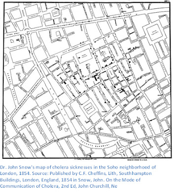
The godfather (not that kind!) of modern day spatial analysis, and of an often linked science known the method used to find the causes of health outcomes and diseases in populations;  http://www.cdc.gov/careerpaths/k12teacherroadmap/epidemiology.html) was a doctor named John Snow. Yes, like from Game of Thrones, although arguably much more heroic (although less immortal). Doctor Snow was an English physician in London during the mid 1800s. In many GIS and epidemiology texts, he is rightly credited for his investigation into the cause of a cholera epidemic in London in 1854. At the time, many doctors and public health officials thought that disease was spread by “miasma”, or bad air. While we know now that some diseases are indeed airborne, many others are spread through media such as water. Dr. Snow wasn’t as fortunate as us to know about germs, but he also didn’t believe that cholera as being spread through the air in a toxic “miasma”. So he took to the streets, and with the help of a local reverend surveyed the residents of the neighborhood in Soho where the outbreak was worst. From his survey, he produced what many consider to be one of the first recorded instances of spatial analysis. It was a map that tallied the number of people who had become ill due to cholera. In the map, the black bars represent individuals, and they are tallied up per household along each street.
as epidemiology (which the US Centers for Disease Control defines as “
While somewhat hard to read, one can see that the bars are thickest at the center of the map, on Broad Street. This was where the most sicknesses occurred, and this trend let Dr. Snow to believe that the cholera was coming from a water pump on Broad Street. We know today that cholera bacteria are transported primarily through water, but at the time, Dr. Snow was met with much resistance from local officials, although he did succeed in shutting down the tainted pump. Consequently, the cholera outbreak was contained, and many people avoided sickness thanks to his efforts. (Source: Gunn, S. William A.; Masellis, Michele (23 October 2007). Concepts and Practice of Humanitarian Medicine. Springer. pp. 87–. ISBN 978-0-387-72264-1.)


Today, GIS is an integral part of public health planning and disaster response. During the ebola epidemic of 2014-16, governments and public health non-profits used GIS to analyze where
Source: http://www.who.int/csr/disease/ebola/maps/en/index1.html
outbreaks were worst, and where they might be heading. This allowed them to prioritize resources to the heaviest hit areas, and ultimately contain the epidemic, although at a high cost in lives. Without the visualization provided by GIS, decision makers would have made blind decisions, which could have extended the epidemic. The map below uses “graduated symbols”, or symbols that get bigger or smaller depending on what they represent, to show the number of ebola cases in different districts of Guinea, Liberia, and Sierra Leone in West Africa. By comparing the size and color of the symbols, they could see where ebola cases were decreasing, and where they were increasing.
 
 
GIS and the Environment

GIS has also provided a great many benefits to the managers of our world’s natural resources. All over the world, changes are taking place to the environment that will affect life on earth in many different ways. GIS has been used to map and predict sea level rise due to global climate change, identifying areas that will see the most inundation, and giving people in those areas more information they need to prepare and adapt.
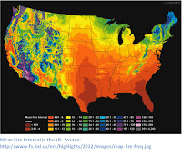

Maps have also helped forestry managers right here in the US identify where forests are struggling to survive due to drought, tree-killing beetles, and other threats from a changing climate. The map below shows how often fires occur in different parts of the US, which will help forest managers make decisions about where to apply fuel-suppressing treatments (burning dead wood to reduce the risk of fire) or other strategies to revitalize dying forests. Forest fires can affect millions of Americans with bad air quality, destruction of infrastructure and homes, and also contributes greenhouse gases to the atmosphere.


GIS in Local Government
Chinese Holy Field Plan
While not the most glamorous or the most global in perspective, GIS used in local government often has wide ranging effects on where, how, and how well we live day to day. City planners have been literally deciding where we live for centuries, and their decisions are informed and enforced by maps. In ancient China, cities were often laid out as a representation of the Holy Field, which was a philosophical concept related to numbers. In the modern day, new philosophies inform how people and activities are grouped together. For example, it is often desirable to keep heavy industry away from residential areas or environmentally sensitive areas such as wetlands or streams. Many cities and counties adopt zoning rules which decide how land is used, although there are many notable exceptions around the world (or better or for worse! I’m looking at you Houston!). 
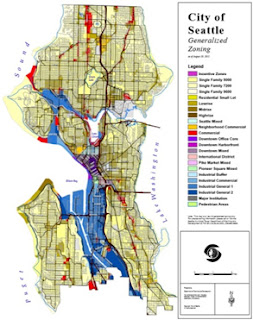
GIS analysis of traffic patterns and public transit use helps governments plan out road, bus, and rail expansions. As traffic is one of the biggest headaches in the lives of most Americans, imagine how bad it might be if we had no idea where the clogged routes are, and where the alternatives lie. GIS enables informed decision making.


Citizen GIS
We’ve covered a few different ways GIS is used to better our lives. Be sure, there are many more, and probably a few not-so-good ways as well. If you made it through all this, you might think, wow, GIS is very exciting, but too hard for me to understand or contribute to. That is where you are wrong! There a variety of ways that any citizen with a smart phone or a computer can contribute to the field of GIS, for the betterment of all life on earth. Here are just a few:

·         Open Street Map. OSM is “the Free Wiki World Map – An openly licensed map of the world being created by volunteers using local knowledge”. Anyone can quickly and easily learn how to add to the map. Add your house, or different features around your neighborhood such as trails, parks, restaurants, etc. https://www.openstreetmap.org/
·         Missing Maps: This program, founded by the Red Cross and others, directs the improvement of Open Street Map by targeting where maps are missing in the world’s most vulnerable places and recruiting citizen mappers to improve them, from the comfort of your own home! http://www.missingmaps.org/
·         Find It Fix It: Find It Fix It is a public service request app by the City of Seattle. Many cities and counties have similar apps downloadable on the Google Play or Apple store. Find out if your city has a similar map app, and start helping to improve the area you live! https://play.google.com/store/apps/details?id=gov.seattle.searequests&hl=en
·         What’s Invasive: What’s Invasive is an app that turns you into a citizen scientist! You can report where you observe potential invasive species, help managers respond before it is too late! https://play.google.com/store/apps/details?id=edu.ucla.cens.whatsinvasive
·         For other crowd-sourced apps and websites, see this article: https://www.scientificamerican.com/article/8-apps-that-turn-citizens-into-scientists/


Tuesday, November 1, 2016

Prime Meridian Day a.k.a. Time Truly is a Relative Thing

On November 1, 1884, representatives from 25 countries met in Washington, D.C., "to fix a meridian proper to be employed as a common zero of longitude and standard of time reckoning throughout the globe", in other words in order to establish an internationally agreed upon 0 longitude and to use that as a zero point for also establishing a worldwide time standard. Twenty-two of the 25 represented countries agreed that the prime meridian should be established in Greenwich, England. This established the standard Greenwich Mean Time (GMT), which is now Universal Time (UTC).


Establishing universal time, let alone a longitudinal "0" location to attach that time to, is a human construct. These constructs are important because they help us to communicate/identify our location (in time and space ; ) in a way that we can specifically define. Establishing a prime meridian was especially important for mapping, navigation, travel, and scheduling.

Science uses many "constructs" to let us explore, research, identify, and communicate about the world. A good example is types of measurement (weights, distances, volumes...), which we have largely standardized, but even the differences in using inches vs. centimeters, miles vs. kilometers, and gallons vs. liters causes confusion, etc..
Establishing a prime meridian/ universal time was and is also important culturally because it demonstrates our global interconnected-ness and gives us common ground.

Fun Fact: Knowing where you are on earth (longitudinally) means that you can figure out what time it is, and visa-versa: every 15° longitude equals an hour difference in time.